

An unposted c1920 postcard of Clara mountain and the valley below entitled “Mount Clara and Valley, Millstreet, Co.Cork”, which is currently on sale on eBay. (Click on the photo for a bigger clearer photo).
Anyone have an idea from where it was taken, and what house is in the right foreground?
=======
Some of the doctors that have been in Westbourne
-
- 1907 1914 1919 Richard Radley Leader
- 1939 1945 1951 1955 : Dr Mary Esther O’Connell (née O’Shea) – CO. CORK DOCTOR APPOINTED The Commissioner acting for Leitrim Board of Health has, on the recommendation of the Appointments Commissioners , appointed Dr. Mary Esther O’Connell (nee O’Shea, of Killinadrush), Westbourne , Millstreet, Cork.[ref]. (Dr. O’Connell’s husband Jeremiah John who had relations in the Derrinagree direction, was also a doctor here when they married in UCC Chapel in 1922. He had suffered a stroke in the late 40’s)
- 1945: Dr. ME O’Connell [1945]
- 1959: John Cribbin (Registrar here from 1951 to after 1969). He was an ex army doctor. Registered first in 1927, and did further studies in the UK.
- Michael Feeley
Though not a doctor, Jim Lucey Station Road became known as Jim the Doctor, as he was the driver for the doctor of that time.!
Other Doctors Locally
- Dr. O’Connor was here some time during the 1940’s (He was an uncle to Tadhg O’Driscoll. His sister was Jerry O’Driscoll’s wife, a teacher in Rathcoole NS. He was a chain smoker!)
- Dr. Pat Casey set up initially in the Wallis Arms in 1965, before moving to the bottom of Tullig.
- Dr. Steven Dillon had a practice at the West End from the early 70’s, setting up initially at the West End (near Christy’s Restaurant), before moving the practice to near the Community School entrance.
TODO : finish the list of doctors
===============
This is the original photo from the Lawrence Collection (about 1909), the full size version can be see at the National Library of Ireland website here
 ========
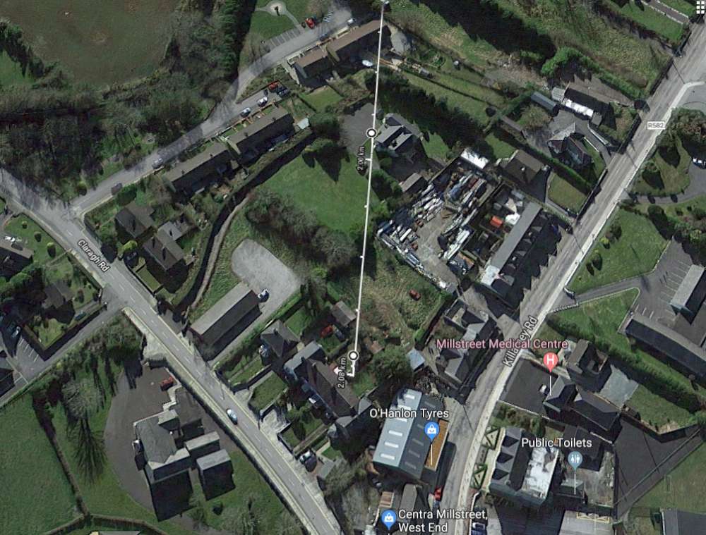
So where was it taken from? In short, the back of the old boys school on Clara Road, across from the Presbytery, which are now dwelling houses.
Plotting a line from the forestry on the north side of Clara to the side of Westbourne House (as in the photo), leaves you at the back of the old boys school. (see the plot lines below)
It was also taken from an elevated position (at first we though it was from an upstairs window, but the school only got an upstairs after it was sold as a school, and a second floor built during its conversion into dwelling houses.
Looking below at the OSI map from about 1900, this is where it would have been taken from. The low walls in the foreground of the original photo match the walls in the map below.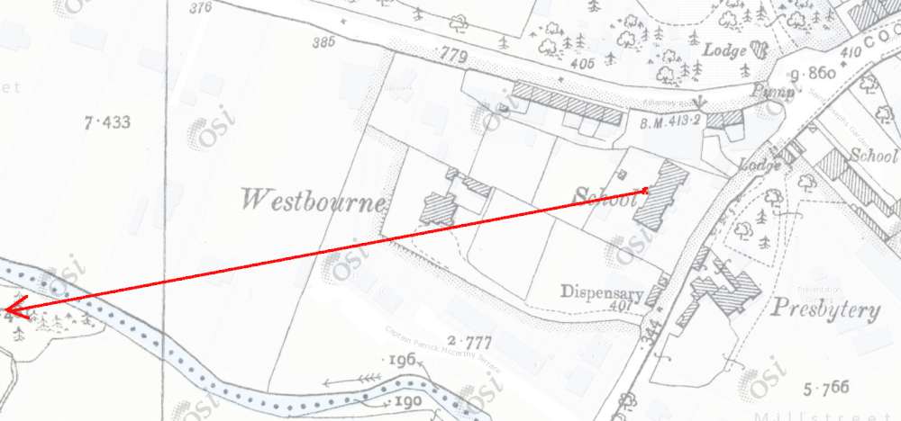 Below is the old Boys National School on the Clara Road. The the photo of Clara was most likely taken from behind this building. This photo is also part of the Lawrence collection.

======