Historical Maps of Millstreet

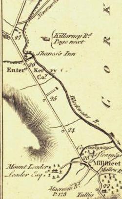
In this article we try to bring together all the old maps which made reference to  Millstreet or some notable place nearby. The first detailed inland maps come from the early 17th Century, until proper ordinance survey maps in the first half of the 19th century. All the maps below give something different on how our area was mapped / perceived. Some of the maps are are not from field studies, but adapted and combined from other peoples work to produce the map.

You can click on all the maps and see a much larger version, and there are links to the sources of all maps, most of which are much larger maps of Cork, Munster or Ireland.


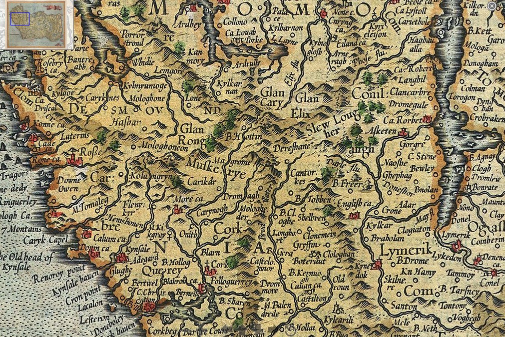
16th Century – McCarthy Sects in the Kingdom of Desmond.
[from Wikipedia – see the Map of Munster] [more on the McCarthys of Desmond]
1920 - 16th Century McCarthy Sects in the Kingdom of Desmond


1595/1606 Mercator and Hondius Map of Ireland.
Cork is left to middle at the bottom. It shows Dereshane (Drishane), Dromagh (which appears closer to Cork than Macroom!), Magrome(Macroom), Cantorkes (Kanturk), and Glen Elix (The Glen of Ellis, referring to the Ellis family who lived in the area at the time [ref]. The maps of the time were more interested in the costal waterways than what was inland, thus the waterways were enlarged. There are two versions of the map 1595, and 1606, and they differ only by the colouring of the banner
1606 Mercator and Hondius Map of Munster


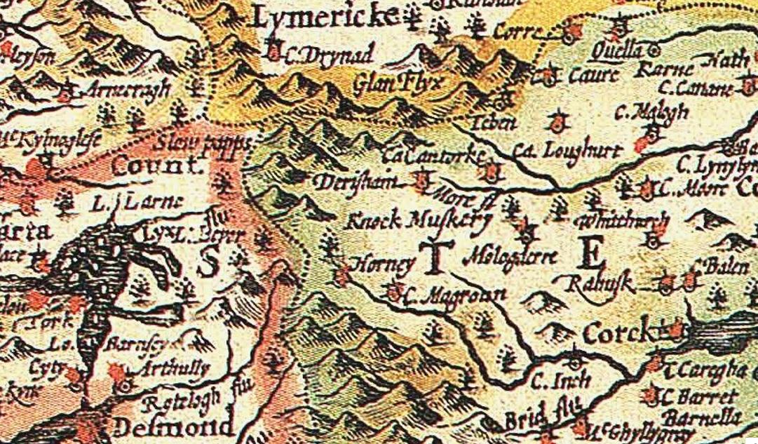
1610 John Speed Map of Ireland: shows Drishane (Derishane), and Mushera (Knock Muskery) [full map] [2.in Black and White] [high quality]

1610 John Speed map of Ireland [read more …] “Historical Maps of Millstreet”

When Ballydaly was once part of Kerry

1797 Civil & Eccleastical Map by Beaufort
1797 Civil & Eccleastical Map by Beaufort which shows the East Fractions to the west of Millstreet and to the north of Cullen (click the map to enlarge)

When looking at historical maps of the Millstreet area from the 18th Century, we noticed that Kerry extended into Ballydaly and a totally detached part of Kerry was just north of Cullen. Intrigued having never heard of this, we did some research, this  is what we found out:

“Referred to as the East Fractions, they were exclaves of the barony of Magunihy in County Kerry. They existed from the suppression of County Desmond in the sixteenth century until 1843, when detached parts were transferred by Richard Griffith under the Valuation of Lands (Ireland) Act 1836 to the adjoining baronies. The fractions were part of the MacCarthy Mór territory from which Magunihy was delimited.”

It is not fully clear as to extent of the fraction around Ballydaly. Officially it was just the townlands of Balldaly and Kippagh, but it is mentioned elsewhere in different places that the Ballydaly fraction included Coolanarney and Coomacheo, and the old maps would seem to support this. We have recreated the map below showing the Ballydaly Fraction and the [read more …] “When Ballydaly was once part of Kerry”

Taylor-Skinner: Millstreet Road Maps from 1777

The images above are from the work of George Taylor & Andrew Skinner’s (both Scotsmen) entitled ”Maps of The Roads of Ireland”. Surveyed in 1777 and published for the authors on the 14th November 1778 in London. Millstreet is included in the roads,

  • p178 Millstreet – Bandon
  • p180 Cork -Millstreet – Castleisland – Tralee
  • p182 Mallow to Millstreet

Click the images to see the the maps that include Millstreet. They all give a slightly different representation of Millstreet.

Notes: In 1776, they sought funding from Ireland’s noblemen and gentlemen in order to map the roads of Ireland.  They succeeded in raising over £2,000 which paid for [read more …] “Taylor-Skinner: Millstreet Road Maps from 1777”