
In this article we try to bring together all the old maps which made reference to Millstreet or some notable place nearby. The first detailed inland maps come from the early 17th Century, until proper ordinance survey maps in the first half of the 19th century. All the maps below give something different on how our area was mapped / perceived. Some of the maps are are not from field studies, but adapted and combined from other peoples work to produce the map.
You can click on all the maps and see a much larger version, and there are links to the sources of all maps, most of which are much larger maps of Cork, Munster or Ireland.
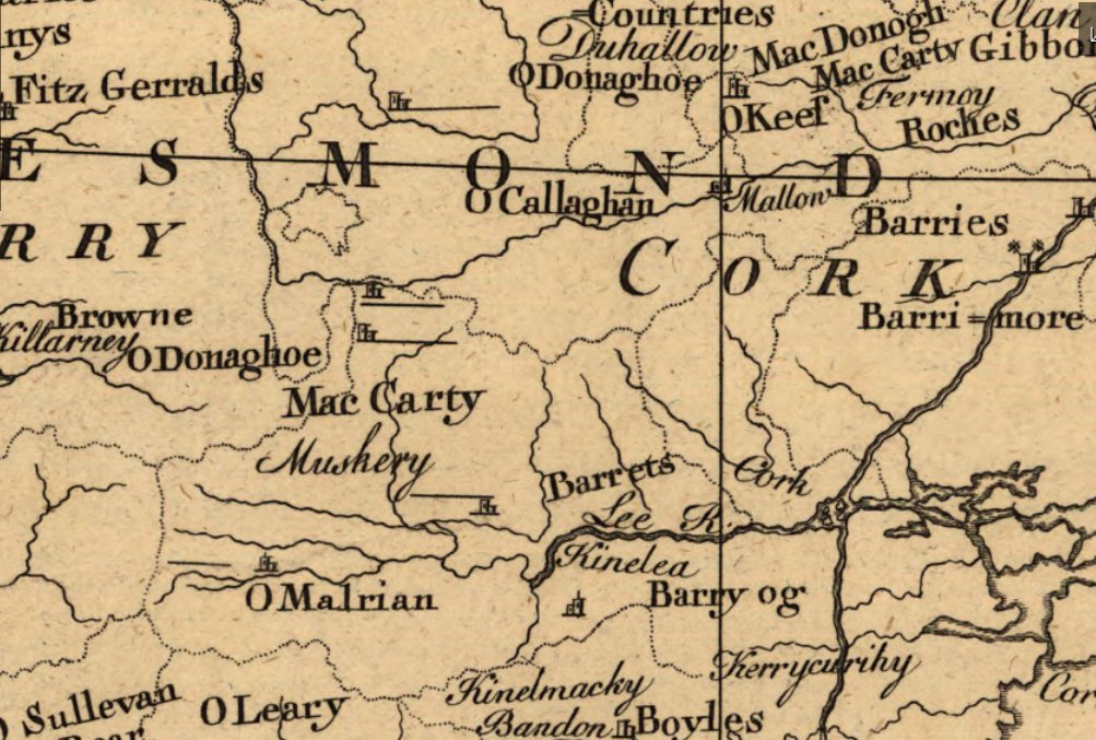
16th Century – McCarthy Sects in the Kingdom of Desmond.
[from Wikipedia – see the Map of Munster] [more on the McCarthys of Desmond]

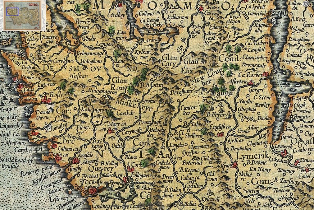
1595/1606 Mercator and Hondius Map of Ireland.
Cork is left to middle at the bottom. It shows Dereshane (Drishane), Dromagh (which appears closer to Cork than Macroom!), Magrome(Macroom), Cantorkes (Kanturk), and Glen Elix (The Glen of Ellis, referring to the Ellis family who lived in the area at the time [ref]. The maps of the time were more interested in the costal waterways than what was inland, thus the waterways were enlarged. There are two versions of the map 1595, and 1606, and they differ only by the colouring of the banner
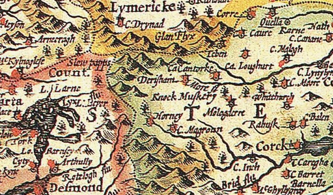
1610 John Speed Map of Ireland: shows Drishane (Derishane), and Mushera (Knock Muskery) [full map] [2.in Black and White] [high quality]
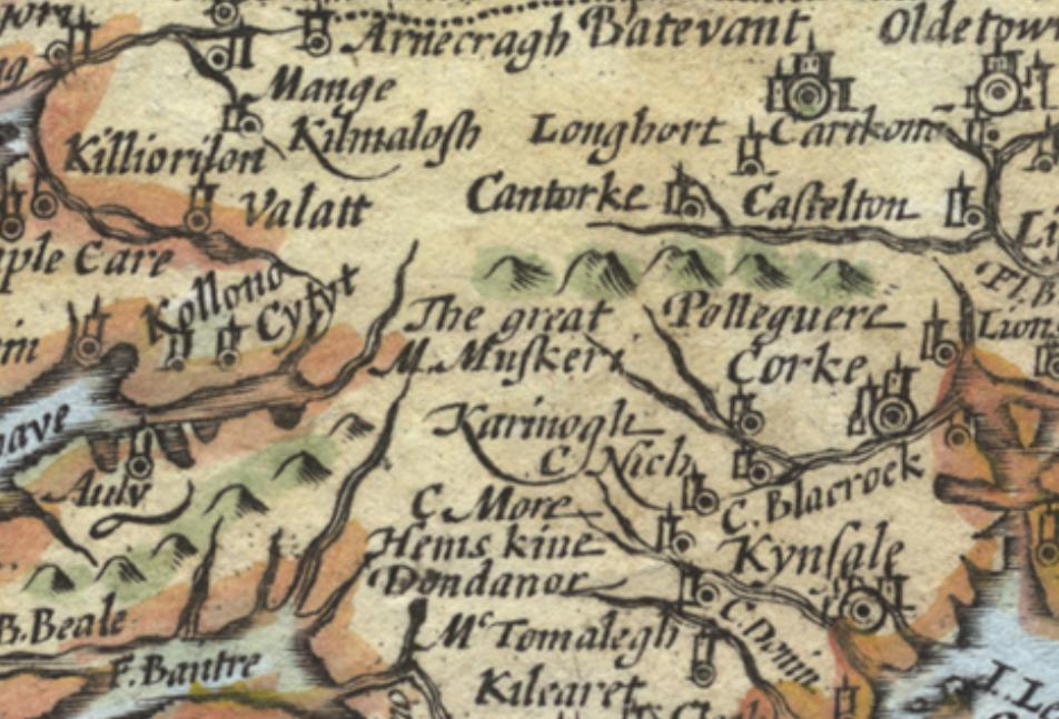
1627 Munster Peter Van Den Keere
shows”The Great Mt Mushera” [full map of Munster]
1628 Mercator and Hondius
released essentially the same map as in 1606, but this time north is at the top. Again it shows Drishane, Dromagh, and Mushera, but their locations are all over the place [full map of Ireland] [1611 version]
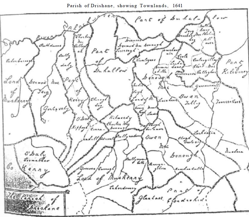
1641 – Hand drawn map of the Parish of Drishane
showing Townlands (from “Aubane – Where in the World is it?” page 20)
1654 Map of Munster by Joan Bleau (Copperplate engraving) [zoomable map]
1659 – Down Survey County Maps
See the full map of County Cork
1670 Down Survey Barony Maps
These show the parishes, townlandsKilcorney and most of Drishane Parishes are in Muskerry, while Cullen, Dromtariffe, Nohavall, and a part of Drishane Parishes are in Duhallow.See the Barony of Muskerry mapSee the Barony of Duhallow map


1670 Down Survey Parish Maps
made after Cromwell’s conquest of Ireland.
Parish of Drishane & Kilcorney Map
Parish of Cullen Map
Parish of Dromtariffe Map
Parish of Nohoval Map


1685: A General Map of Ireland, by William Petty (1623-1687)
It’s interesting that Millstreet is not mentioned on the map as it hardly existed at the time. Cullen and Dromagh are shown. [See the full map of Ireland]
 —
—
1697 Irlanda Parte Meridionale – by Vincenzo Coronelli
[map of Southern half of Ireland]
Glan Elix appears again, Dereshane, Dromagh, and the Blackwater is called ‘Brod Water ó More F’. Placement on the map isn’t very good, and Carykphok castle has taken a trip to the north of the county.

1680 Regnum Hiberniae – by Matthaeus Seutter
[map of Ireland]
This map may be from 1755 (not sure). What is ‘B.Elogh’ above Kilcorney where Millstreet might be?
Jean-Baptiste Nolin – Le Royaume D’Irlande Divise en Provinces subivisees en Compte et en Baronies selon les Memoires du Sr. Petty . . . Paris / 1690 (1700)

1692 L’Irlanda o vero Hibernia – by Giovanni Giacomo de Rossi
[full map of Ireland]

1708 Le Royaume D’Irlande – by Alexis Hubert Jaillot
[map of Ireland 1][Map of Ireland 2]
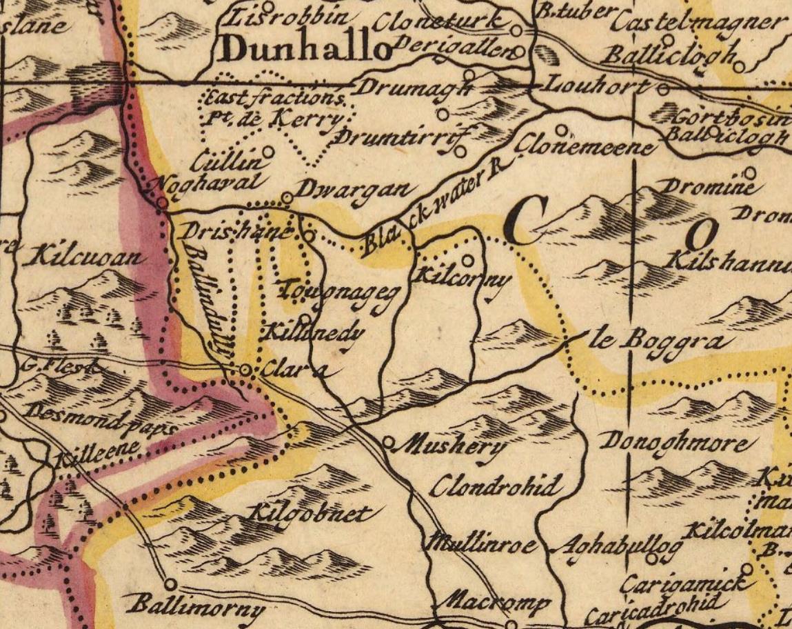
Ballindully (Ballydaly), Killinedy (Kilmeedy), Clara, Kilcorny, Dwargan (Dwarrigle), Noghaval (Nohoval) Drumtirrif (Dromtarriffe), Clonemeene (Clonmeen, Banteer). But what is ‘Tougonageg’ just above Kilmeedy? It’s also important because it’s one of the few maps that shows the road from Macroom to Killarney over the county bounds.
1714: A New Map of Ireland, by Herman Moll
This is the first map we have found which shows Millstreet. [See the map of Ireland in full]. A very similar map by Moll from 1726 can be seen here but in less detail
1716 Homann Map of Ireland
[full map of Ireland]

http://hdl.huntington.org/cdm/
1749: A Correct Map of Ireland
Divided into it’s provinces, counties, and baronies showing the roads and the distances of places in computed miles by inspection, where barraques are erected & c. London. Printed and Sold by Thos. Jefferys Geographer to his Royal Highness the Prince of Wales at the corner of St. Martins Lane in the Strand, and by W. Herbert on London Bridge. 1749 [full map]

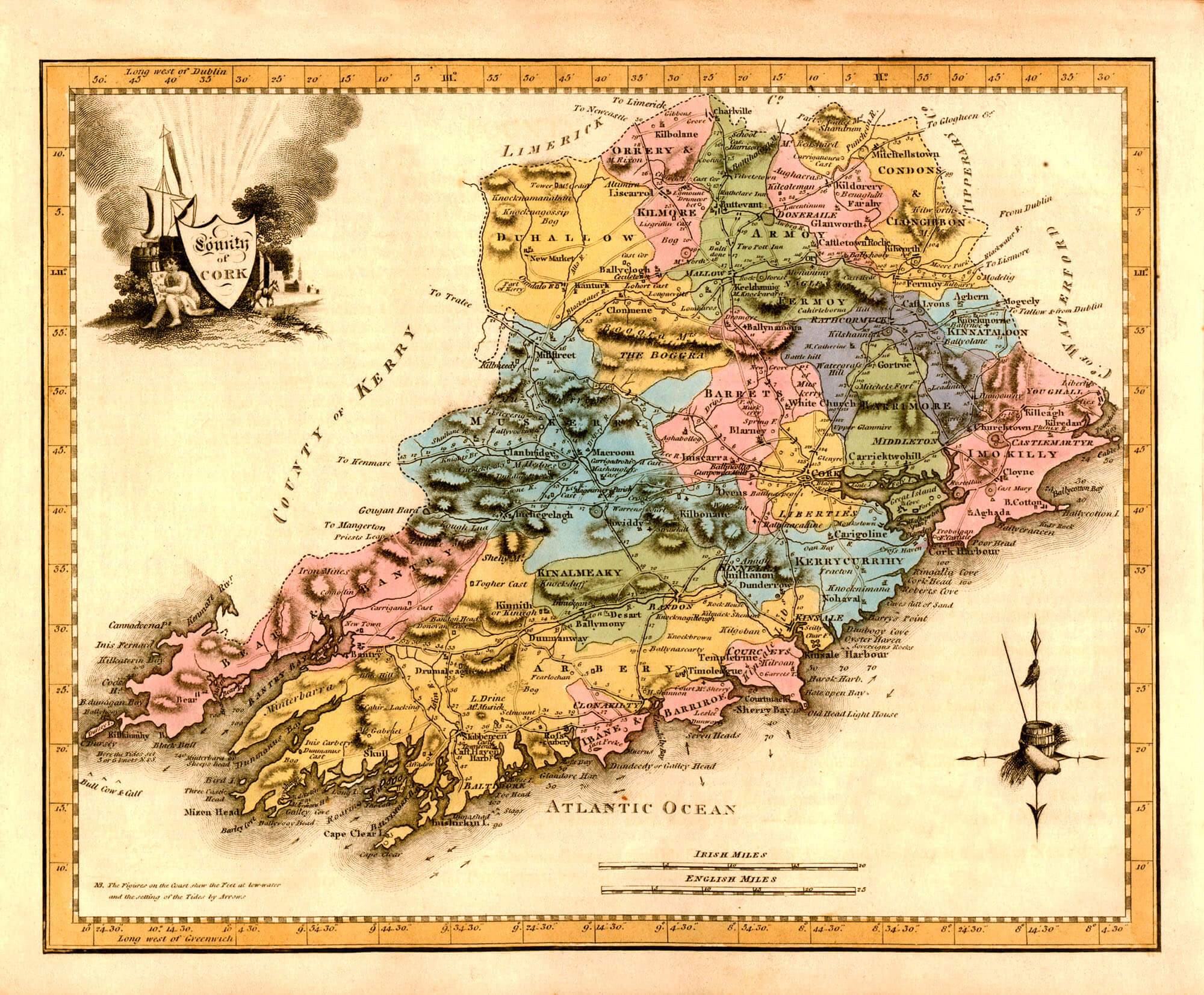
1750 – Smith’s Map of Cork County
It appears to show the Butter Road (Castleisland to Cork, via Millstreet), which was commissioned in 1747, but it was hardly built in 1750 [See the full map]
A New and Correct Map of the County of Cork : To the Nobility and Gentlemen of this County / this Map drawn from an Actual Survey is inscribed by their most obedient humble servent, Ch. Smith ; Ridge Sculp.t | Charles Smith (songwriter) 1750 [full map] Smith’s map again, but this time is better detail and with more locations.
—
1754 – French – Les Isles Britanniques qui comprennent les Royaumes d’Angleterre, d’Ecosse et d’Irlande; par le Sr. Robert Geographe Ordinaire du Roi – by Robert de Vaugondy, Gilles
(The British Isles, comprising of the UK, Scotland and Ireland) [see the full map]. Vaugondy had a similar earlier map in 1750 but we don’t have a detailed version [see it here]. He also had an ever earlier map from 1748, which is a bad attempt [see it here]

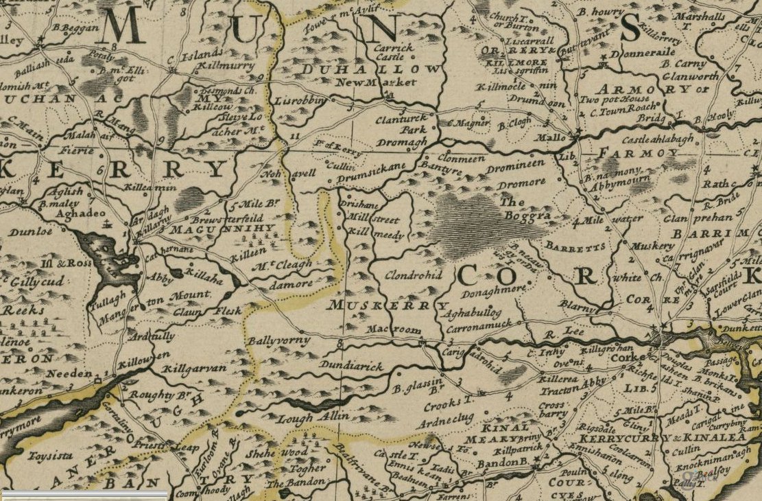
1760 Thomas Kitchin / London Magazine: A New Map of the Kingdom of Ireland, Divided into its Provinces & Counties: Drawn from the best Authorities. [Full map of Ireland] It shows Claragh, Banteer, the Blackwater rising south of Clara

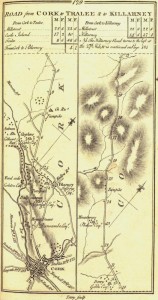
1777: Taylor Skinner Road Maps of Ireland.
These included maps from Millstreet to Bandon, Cork to Millstreet to Castleisland to Tralee, and Mallow to Millstreet. [Read the article we had on the maps which showed the four main routes through Millstreet]
1778 Provinces of Connaught and Munster, by Antonio Zatta
Places mentioned: Drashane (Drishane), Killinedy (Kilmeedy), Dwarggn (probably Duarrigle), Cullia (Cullen), Drumtirriff, and the East Fractions
[full map 1][full map 2]

1782 A New Map of Ireland with the Roads
John Lodge [full map of Ireland] (not detailed, but shows Millstreet and Kilmeedy)

1790 – A map of the Kingdom of Ireland
divided into provinces, counties and baronies. Southern section. Shewing the archbishopricks, bishopricks, cities, boroughs, market towns, villages, barracks, mountains, lakes, bays, rivers, bridges, ferries, passes, also the great, the branch & the by post roads together with the inland navigation, by J. Rocque, Chorographer to His Majesty. London, printed for Robt. Sayer, opposite Fetter Lane, Fleet Street. [Full map of Ireland(wiki 1794)] [Full map of Ireland]

1790 – Neville Bath’s map for the Grand Jury of Cork
was surveyed in the 1790s and published in 1811.The map is one of the best and most detailed maps of the county before the Ordnance Survey maps of the 1840s. It is a treasure trove for geographers, historians, and place-name specialists. [All Grand Jury Maps of Cork]
1790 Bowes New One
Sheet Map Of The Kingdom Of Ireland [Full Map of Ireland] A similar map by Bowes with the names in English font from the same time can be viewed here

1795: Ortelius Improved, or a new map of Ireland
Wher in are inserted the principal families of Irish and English extraction, who possess’d that kingdon[sic] on the commencement of the seventeenth century. [full map of Ireland]
1795 Charles Vallency’s Military Survey Map of Ireland
(image below is the cover page of “Millstreet – A Considerable Town” by the Aubane Historical Scoiety). Vallency’s work which was of the lower half of Ireland was never finished, but remained in manuscript.

1797: Civil and Eccleastical Map of Ireland by Revd. Daniel Agustus Beaufort [See the full map of Ireland].
Beaufort wrote a memoir on the completion of the map [read the memoir]
1798 William Faden’s Pocket Map of Ireland
shows Drishane as the main route between Cork and Kerry, and also Kilcorney, but no mention of Millstreet
[full map of Ireland 1][full map of Ireland 2]

1799: A New Map of Ireland, Divided into its Provinces and Counties, by John Cary (engraver)
Shows Millstreet, Cullen, Drishane, Kilmeedy, Kilcorney and Dromtariff [full map of Ireland]

1799 map of Ireland by the English map publisher Clement Cruttwell.
Map shows Ireland’s four provinces, counties, towns and roads. [full map of Ireland]

1803 Map of Ireland (J.H. Fleming)
[full map]

1804 Jeffreys and Kitchin Map of Ireland
[full map of Ireland]

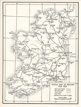
1805: A map of the mail coach, branching cross and bye post roads of Ireland: Author Larkin, William, fl. 1802-1819. Millstreet was the main staging stop between Cork and Killarney. See the full map of Ireland.

1805: There is a similar map from a little later from the same time also by Larkin on page 13 of Millstreet – a Considerable Town by the Aubane Historical Society which shows the main Cork-Killarney route going through Macroom and Millstreet, and not over the butter road. (We have another version of the same map, showing Cork Limerick and Kerry, but it is less clear). By 1832 the Postal Map of Ireland 1832 had the Mail Coaches going straight from Macroom to Killarney over the county bounds


1811 -Ireland.
London, Published 4th January 1811 by A.Arrowsmith on linen, Hydrographer to H.R.H. the Prince of Wales, No. 10 Soho Square. [full map of Ireland]

1812 Kerry and Cork by Longman
[A Millstreet Miscellany 4 (page 7)]
1813 map – John Pinkerton’s modern atlas
he has some explaining to do as to how he got that result!
[full zoomable map]

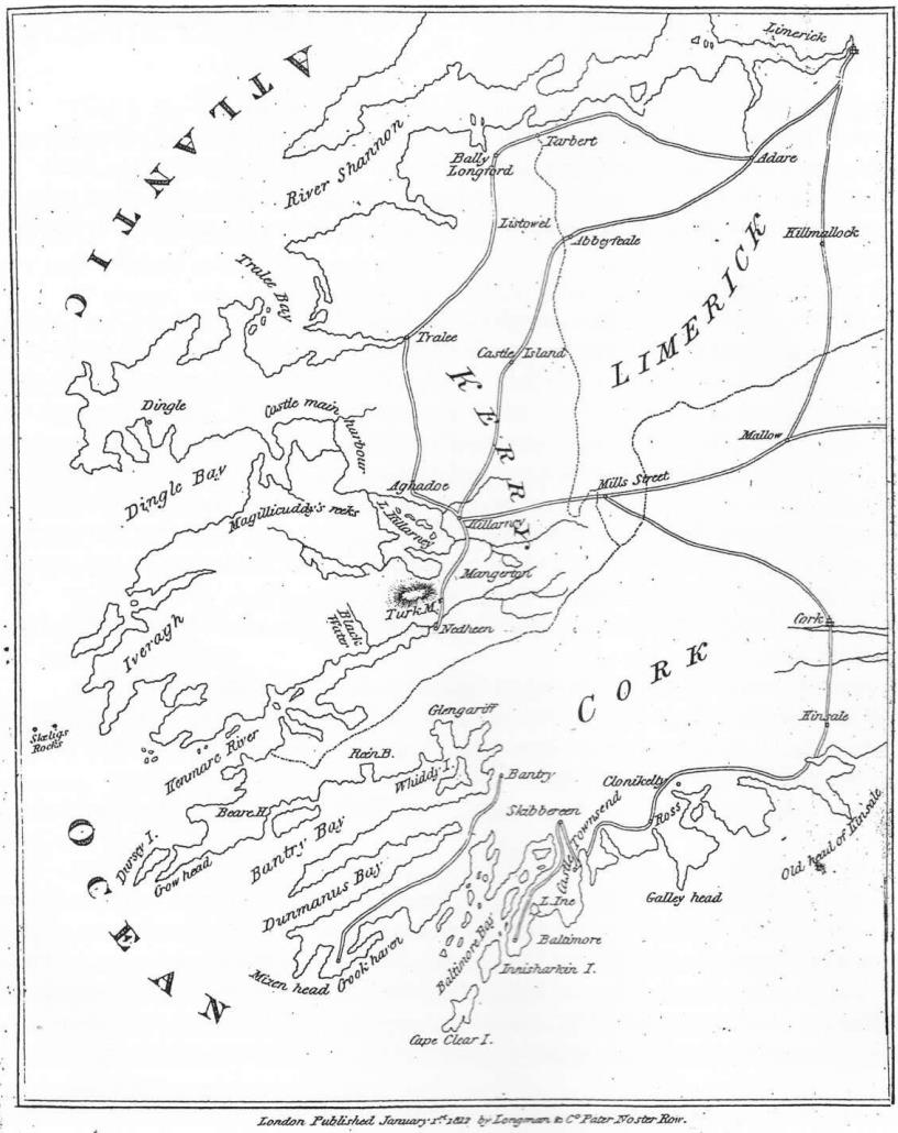
1814 Thomson Map of Southern Ireland [full map] This is interesting for a number of reasons.
- It shows that via Millstreet was the main route from Cork to Killarney. The Butter Road over Mushera was the main route at the time.
- It is also the main route from Mallow to Killarney, as the Sandpit House to Rathmore had yet to be built. It also shows that everything west of Kanturk in Duhallow and north of Millstreet was part of County Limerick (I’ve never heard this to be the case).
- The map shows the Ballydaly fraction, but not the Cullen fraction !
- Ballydaly seems to be named as “Aghncliur”. Probably a misspelling of Annagloor, the small river that flows nearby.
1817 Ireland by Robert Kirkwood
[full map of Ireland]

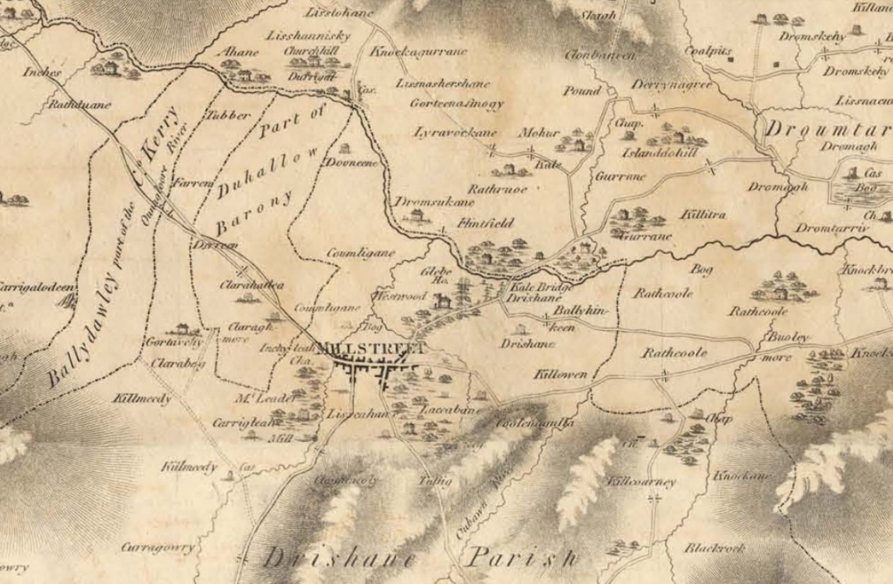
1820s Map of Munster by Nicholas Leader MP, who at the time owned the coalpits in Dromagh. (Image below is from page 23 of “Millstreet – A Considerable Town” by the Aubane Historical Scoiety, and is explained on page 39 of the same)

1823 Ireland and Counties – by John Grierson
[Cork map]

1827 – Partie de l’Angleterre. Europe no. 12. (Dresse par Ph. Vandermaelen, lithographie par H. Ode. Premier partie. – Europe. Bruxelles. 1827). Hard to know how some of the places (like Fermoyle & Pluckanes) got onto the map while there’s no sign of Macroom, Kanturk or more [map of Ireland, UK and France]

1829 Lapie Map of the British Isles [full map of the British Isles]

1830 – Britisches Reich. C. Kon: Ireland. d. Prov: Munster. Counties: 27-32 … (to accompany) Atlas von Europa nebst den Kolonien : Funfzehnte Lieferung. Leipzig bei Georg Joachim Goschen 1830. Author : Schlieben, Wilhelm Ernst August. Author: Hermann, O. [full map of Munster]

1832 Ireland by Carey & Lea (USA) – have placed Millstreet in County Kerry, but may have gotten confused with the Diocese of Kerry, and strangely have another Millstreet in North Kerry [map of Ireland]

1831 Ireland, southern sheet. Published by Daniel Lizars, Edinburgh. This is important because it shows the Mail Coach Route along the Butter Road

1833 Cary – Large Format Case Map of the British Isles – Comprehending the whole of the Turnpike Toads, With the Great Rivers and the Course of the different Navigable Canals, also the Market and Borough Towns and Villages adjoining the Road, to which is added The actual Distance from one Market Town to another, with The exact admeasurement to each from the Metropolis. [geographicus.com]
 This is a version of the same map, but with mountains

1830s Ordinance Survey Map of Ireland (6″) [full interactive OS map of Ireland] [note: this is the very best map for historical detail]

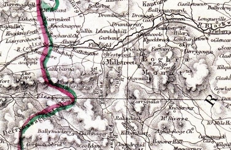
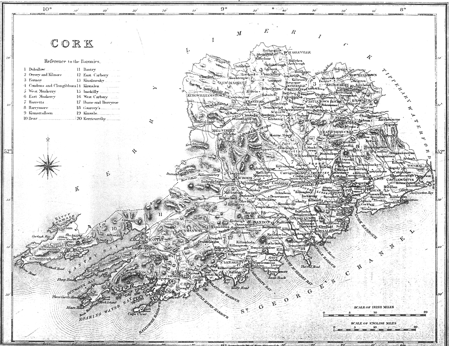
1837 Map of the Baronies of Cork (part of the Lewis Topographical Dictionary) See the ful map of the Baronies of Cork

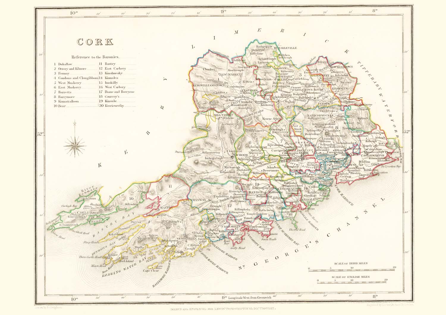
County Maps of Ireland – Lewis Directory of Ireland 1837 – Map of Cork with reference to the Baronies (Year unknown, from its style it’s probably mid to late 19th century) [Cork County] [2]

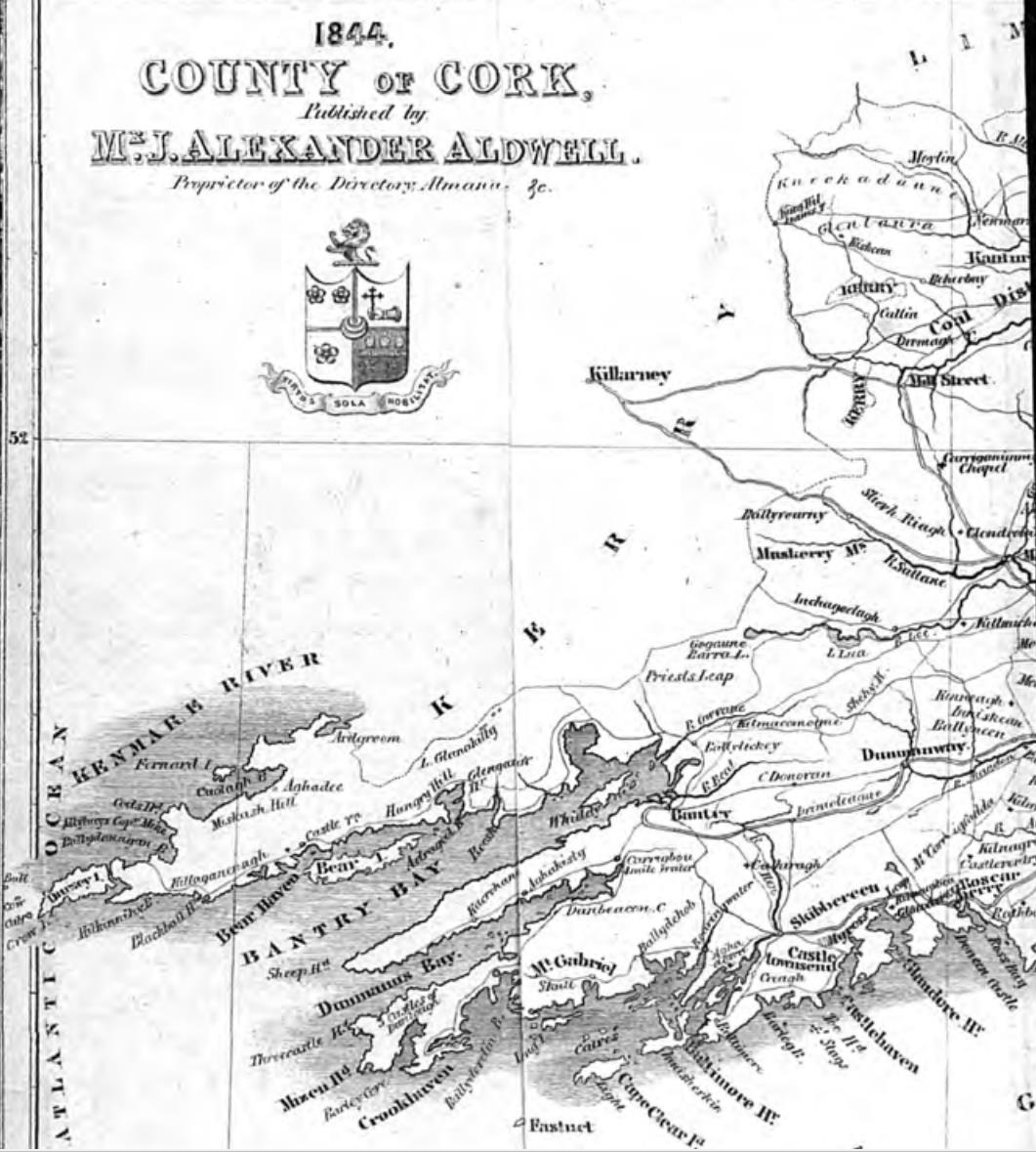
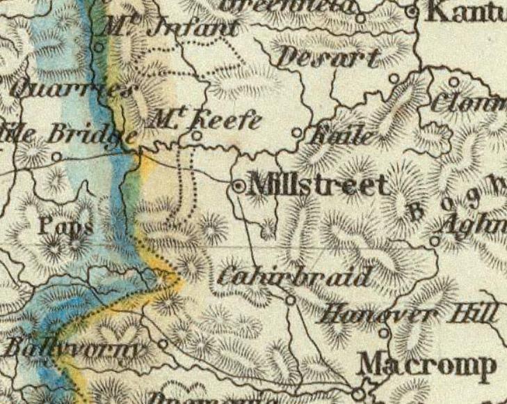
1844 Society for Diffusion of Useful Knowledge – eng. by J. &. C. Walker, reprinted by Chapman & Hall, London 1844 – Dromagh is labelled as the “Coal District” [full map]
Another version of the same map appears in the 1844 version of Guy’s Directory of Cork City and County (below)
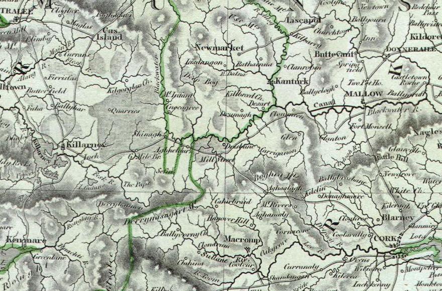
1844 Map Ireland, By John Arrowsmith
[full zoomable map]
Ounnagloore (Annagloor), Church Hill, Mohar, Westwood, Dromtariv, and Carrigulla make the map.
1844 Map Ireland by Carl Christian Franz Radefeld – Methinks this German needed spelling lessons
[full zoomable map]
1849 Mitchell Map of Ireland.
From the New Universal Atlas of the World by Samuel Augustus Mitchell, an American geographer.
Not much really, but still showing the fractions which were removed 6 years earlier. Possibly derived from an older map? [map]

1850 Ireland by Sidney Hall. Showing Millstreet, Carriganima Chapel, Cullen, and Dromtarriff. (it may be from after 1850 as it shows Millstreet Railway Line (opened 1853) [full map of Ireland]
This is the first map to show the fractions after they were integrated into Cork in 1843 🙂

1851 Black Map of Ireland in Provinces – Cullen is shown as Churchill [full map of Ireland]

Poor Law Unions – Pre 1849 & after 1849.
See the full post-1849 map of Workhouse unions in Ireland
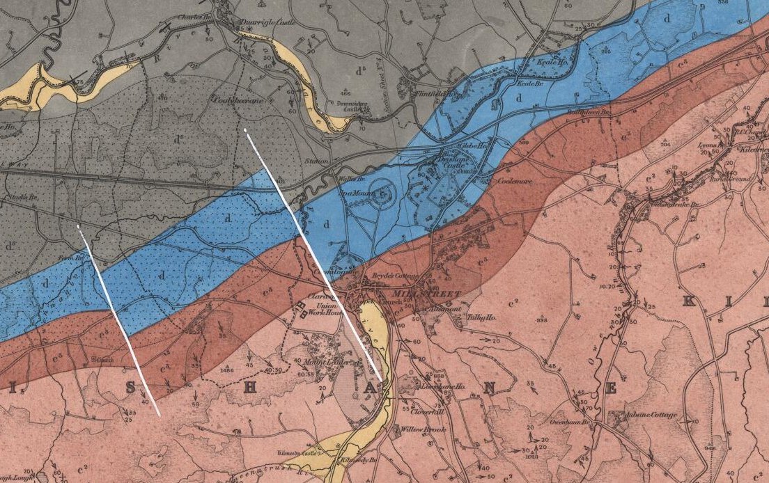
1860: Geological Maps – showing soil types (red=sandstone, blue=limestone, grey=coal measures, yellow=alluvial), fault lines etc. (TODO figure out what maps the colours are overlaid on)
| 174 | Millstreet | Solid | 1860 | Full entry |
| 174 | Millstreet | Solid with Drift | 1859 | Full entry |
| 174 | Millstreet | Solid with Drift | 1882 | Full entry |
| 174 | Millstreet | Solid with Drift | 1913 | Full entry |
1864 Johnson Map of Ireland and Scotland – first to show the Millstreet train line [full map of Ireland]

Map of Ireland c1867 (Blackie / Weller) [full map]
1879 Map Keith Johnston’s General Atlas of Ireland
[full zoomable map]
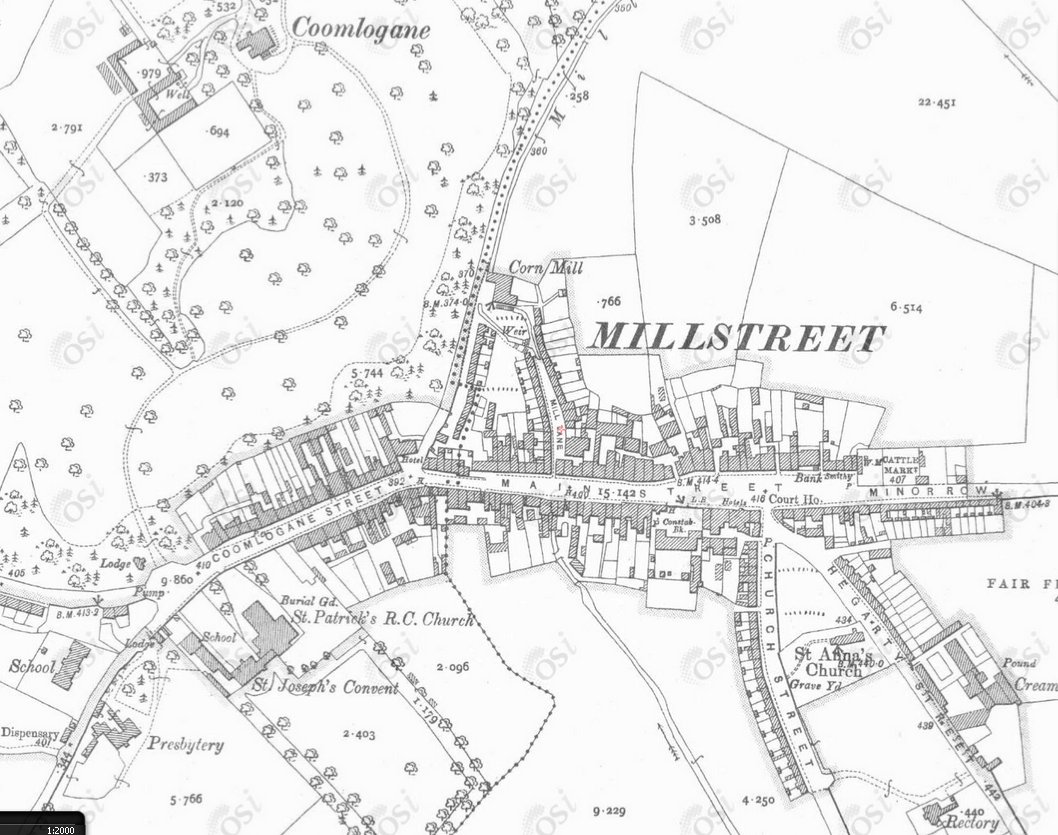
1890 Ordinance Survey Map of Millstreet (12 inch)
See the full OS map of Ireland
1896-1900 County Maps of Ireland by Robert Lloyd Praeger (Philips’ Handy Atlas of the Counties of Ireland) Interestingly shows Aubane Cottage. See the Map of Cork and other Counties

1901: Ireland South West by Edward Stanford
[full zoomable map]

1904 Philips Atlas of Ireland
[full maps]

1922: Ireland – southern section. The Edinburgh Geographical Institute, John Bartholomew & Co. “The Times” atlas. (London: The Times, 1922)

1935 District Electoral Divisions..See the full Map of the South of Ireland

1940 British War Maps of Ireland
See the zoomable map of Killarney

Map of the Baronies of County Cork (Year unknown, probably early 20th century)

Léarscáil na hÉireann, 1948 was used in the schools as a map of Ireland as gaeilge. [Full Map of Ireland]. Sráid an Mhuilinn (Millstreet), an Abha Mhór (the big river or the Blackwater), and the rail lines are in red.

Discovery Map of Ireland (year unknown, maybe 1960s or later), which puts the townland of Carrigacooleen on a par with Millstreet, removes the Butter road, and does many other strange things [full map of Cork]
============
Some Questions:
What does Glan Flyx seen in maps from the 1600s refer to?
Why is Aubane Cottage so prominent in maps around the 1900s?
==============
Maps of Ireland with a Special Focus on Ancient and Medieval Irish Tribes and Septs
(No mention of Millstreet here – from Rootsweb)
B.C. xxx – Ice Ages and the Arrival of Humans.
B.C. xxx – Neolithic, Bronze and Iron Ages.
B.C. xxx – Celtic Ireland – Sons of Milidh.
A.D. 100 – Conn of the Hundred Battles – The ‘Annals’.
A.D. 150 – Early People – Ptolemy’s Map.
A.D. 200 – Legendary Kings
A.D. 300 – Royal Provinces and Sites.
A.D. 400 – Arrival of Christianity.
A.D. 500 – Provinces and Tribes.
A.D. 600 – The Golden Age.
A.D. 700 – Kingdoms and Dynasties.
A.D. 800 – The Viking Era.
A.D. 900 – Viking Settlement and Impact.
A.D. 1000 – Age of Brian Boru, Kingdoms & Settlements.
A.D. 1100 – Pre-Norman, Territories and Surnames.
A.D. 1200 – Norman Invasion, Irish Surnames and 1st landings.
A.D. 1300 – Medieval, Irish and Anglo Surnames.
A.D. 1300a – Counties, Liberties & Irish Dynasties. (Kerry people won’t like this one 😉 )
A.D. 1400 – Gaelic Resurgence – Boundaries of Lordships.
A.D. 1500 – Counties & Chiefdoms.
A.D. 1600 – Plantation and Earldoms.
A.D. 1700 – Protestant Ascendancy.
A.D. 1800 – Defense and Rebellion.
A.D. 1840’s – Years of the Great Famine.
==============
Other Maps
1530 Clans of Ireland during the time of King Henry VIII
1595 Ortelius Map of Britain and Ireland, also of Europe
1631 Blaeu Map of the British Isles (England, Scotland, Ireland)
1783 Janvier Map of the British Isles
1846 Genealogical map: Ancient Ireland – by Philip MacDermott (Link shows the map in “A Millstreet Miscellany” pages 21 to 25)
1861 Map of Ireland, by Edwd Weller F.R.G.S. (no detailed version available)
1896 Biological Vice-Counties Map of Ireland – Millstreet was pretty much split in two in this subdivision !
Modern Maps
Geo Hack has the links to all the global services that show route, satelite, terrain maps and more for Millstreet.
There are many other maps int included above, but they appear to be just copies of other maps (it happened a lot), or had nothing new to offer
====== The TO DO LIST ==========
TODO: Following are references for maps in the British Library catalogue which can be accessed on the internet for further details but the maps themselves may not be online.
- M.T. 11 g.1. (8)
- maps 177.d.2. (8)
- 10805(11)
- KTOP 51.10.2 TAB
- 10805 (103)
- CC 5a 374
- 10835 (2)
- LI/306
- K.TOP. 51.30A
- 10805(11)
- KTOP 51.10.2 TAB
TODO: Get a more detailed version of the pre 1811 map mentioned in A Statistical Survey of Millstreet (1810)
TODO: insert Survey Map of Millstreet from 1901 (Separate)
TODO: add the Civil Parish Maps of Cork
TODO: add the townlands map of Millstreet (separate article)
Michael, what a treasure trove of maps! A fantastic and fascinating resource! I think I am right in noting that not one of them has a word of Irish, the language of most of Ireland when the maps were current. This of course is not surprising as those who commissioned the making of maps always had their own agenda. Thank you for making all these available on your wonderful website. Go maire tú céad!
No, not one of them is as Gaeilge, but since those that compiled them were either British, or European.
There are some other maps referenced (http://www.rootsweb.ancestry.com/~irlkik/ihm/) that have no mention of Millstreet, that go back further and deal with Clans and Septs. These have the Irish family names, but that is as good as it gets.
… and just to clarify, it’s not my website, it belongs to everyone in the community, i’m just the administrator at present.
Michael
This is indeed a fantastic collection and vital to any history of Millstreet. Thanks for all the work involved. It should be made available in some ‘hard’ form.
Jack Lane
Hi Michael,
Came across the website while researching maps. Coincidentally I am putting together a montage of maps of my area to illustrate development or lack of it, visually over the centuries.
One question I have that you may be able to help me with, older maps have local names in Latin. Is there any method or expert available to decipher these long forgotten texts.!?
Again congrats. on a job well done and keep up the local history. Best regards, John