
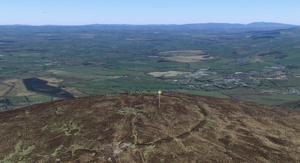
While most of us have been to the top of Clara Mountain, many don’t know that on top, the remains of an ancient hillfort lie under the heather. It can be made out in the photo above which shows Clara with Millstreet in the background. The hillfort is described in a new archaeological site: The Atlas of Hillforts of Britain and Ireland, which maps for the first time all the ancient hillforts across the landscapes of Ireland and the UK:
“Contour fort positioned at the summit of Claragh Mountain, overlooking the town of Millstreet. The circular enclosing element measures 122m in diameter and comprises a single bank of loose stone with no discernible ditch feature. It occupies a total area of 1ha. Possible original entrance at WNW. Up to four breaks in the bank have been created in recent years. Near the center of the interior, a sub-rectangular enclosure, 19m E _ W, 14mN _ S, is defined by a setting of stones. A cairn, 8m in diameter and 0.5m in maximum height is incorporated in to W section of the hillfort bank. Sections of peat at summit suggest an even blanket of peat approximately 0.2m in depth. Some heather growth in interior. There have been no archaeological investigations of this hillfort.
Entrance: Simple break in hillfort bank, 8m wide. West side”
As no archaeological digs have taken place, it is unknown how old the hillfort is, but this may give an idea: “Hillforts are located on and often follow the natural contours of a hill, enclosed by an earth or stone bank/banks and fosse/fosses which can be internal or external. They may have been important ceremonial tribal centres and/or permanent or temporary settlements. They have been dated to the Late Bronze Age (c. 1000-500 BC) with examples of reoccupation in the later Iron Age (c. AD 100-400).”
“The word hillfort was coined in the early 20th century, and perhaps archaeologists at the time had a more military frame of mind, which was why they assumed these buildings were intended to defend against invaders.”
What is believed now is that hillforts were more like Iron Age community gathering places. Professor Lock says: “We’re dealing with prehistoric architecture so we can never say for certain what the true purpose of every one of them was, but we think that most of them were communal meeting places. Most people would have been farmers at the time and spread out across the countryside, to these were places for them to meet up and have social gatherings. They would probably have shared the building and maintenance of them.”
All that remains of these settlements today are earthworks and banked ditches, though there are some, notably in Scotland, where stone walls are still standing. — independent.co.uk
Unfortunately the map used on the Atlas of Hillforts site only shows Clara covered in cloud 🙁 … but fortunately there is a very good view of it on Google Maps which we show below:
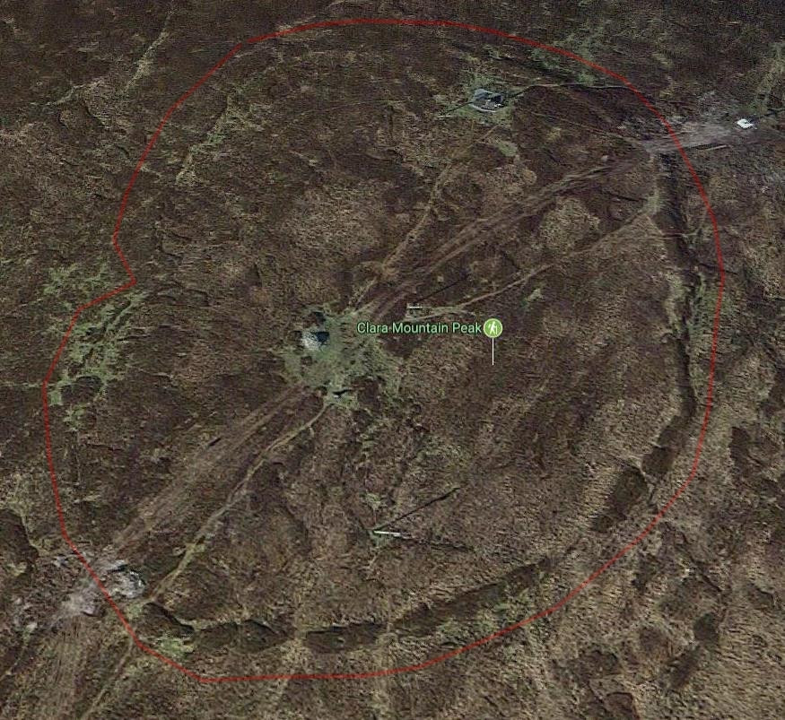 View of Clara Hillfort on Google Maps (satellite view). We have added a light red line outside the walls of the fort to make it clearer. The entrance is on the left where the outline turns in.
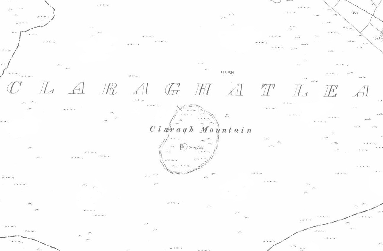
It is also shown in the 1890 OSI map, and at the time there was a Sheep Pen at the summit! (click the map to see it larger)
===============
The hillfort and cairn are mentioned in the ‘Archaeological Inventory of County Cork. Volume 4: North Cork’ (Dublin: Stationery Office, 2000)
Class: Hillfort (CO039-052002-)
Townland: CLARAGHATLEA SOUTH
Description: At summit of Claragh Mountain, with extensive view in all directions. Subcircular area (122m E-W; 122m N-S) defined by rubble stone bank (int. H 0.6m; ext. H 1.4m), best preserved NNE->SW; low SW->W; slight traces W->NNE. Possible gap (Wth 8m) to WNW. Close to centre of interior, subrectangular enclosure (19m ENE-WSW; 14m NNW-SSE) defined by band of rubble stone (Wth 1.5m); cairn (diam. 8m; H 0.5m) (CO039-052001-) overlies W corner of enclosure. According to local tradition, priest buried here (Broker 1937, 45) ‘c. 300 years ago’ (Bowman 1934, 318). In 2014, in the process of erecting a cross at the summit, sections of the enclosing bank were removed at NE and SW. Other recent damage within the interior of the monument appears to have been caused during the installation of a telecom station, OS trigonometrical station and ESB poles. (revised 2014)
Class: Cairn – unclassified (CO039-052001-)
Townland: CLARAGHATLEA SOUTH
Description: This cairn is referred to in the ‘Archaeological Inventory of County Cork – vol. 4 North Cork’ (2000, 205) under the entry (no. 11977) for a hillfort (CO039-052001-). It is referred to in the entry as follows: cairn (diam. 8m; H 0.5m) (CO039-052001-) overlies W corner of enclosure. (revised 2009)
===============
— from Clashanimud and the Bronze Age Hillforts of Munster – O’Brien, W. 2016:
… There are three other possible Class 2 hillforts in Co.Cork, located in the northern and eastern parts of the county, some distance from Clashanimud (Fig.1). They include Carntigherna overlooking Fermoy and the Blackwater valley (Masterson 1999), Caherdrinny near Mitchelstown (O’Brien 2012, 217–219), and Rath in East Cork. There is also a Class 1 (univallate) hillfort on the summit of Claragh Mountain (452m OD) near Millstreet (ibid.), as well as a number of smaller hilltop enclosuresin the county. These sites have not been excavated, and so it is difficult to establish their relationship, if any, to Clashanimud hillfort. Their status is uncertain, and while Carntigherna is widely regarded as a Class 2 hillfort, this remains to be confirmed. Clashanimud is presently the only definite example known in Cork…
===============
Name: Claragh Mountain
Name in Irish: Clárach
Meaning: Flat topped (mountain) Oxford Irish Dictionary
Notes about peak and name(s): Mentioned in the saying ‘Ceo ar Mhuisire is Clárach lom, an comhartha soininne is fearr ar domhan’, ‘Mist on Mushera and Claragh is the best sign of good weather in the world’. There is a hillfort on the summit of Claragh. – from Mountaineering.ie

===============
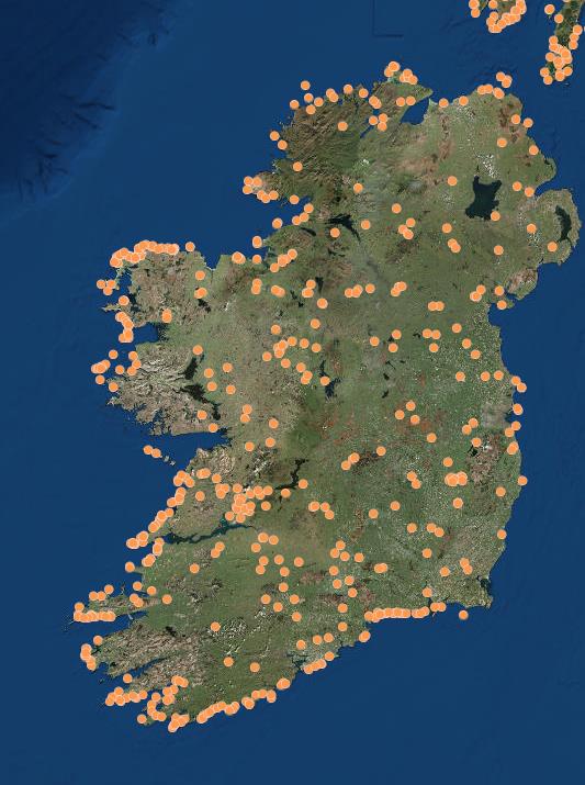
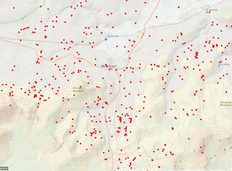
Map of all the hillforts in Ireland: there’s no other hillfort for over twenty miles around Clara, the closest being near Kilmurray
==================
With thanks to Mary Hackett, who alerted us to The Atlas of Hillforts of Britain and Ireland.
Translation of “Ceo ar Mhuisire…” seems to imply that both mountains covered in mist – “lom” means bare.
CEO ar muisire translation.
Mist on mushera
And Clara clear
Is the best sign of good weather in the world.
As taught by Mr.Dick Kiely.Ard Muinteoir.
Nice to see he’s still remembered. Hope you’re well,Derry.
I experienced and photographed a wonderful Winter Solstice Sunset at the “Cnoc na Cille” Stone Circle and Stone Alignment on 22nd (Solstice was on 22nd that year) December last 2019. The sun sank and cast the long shadow of the tall monolith, which shadow bisected the Portal or Entrance Stones of the nearby Stone Circle. Would be glad to share the photos as they could have some tourist potential and also be an inspiration for young people to respect our heritage. It was thrilling to witness as the chances of getting visible sunsets in this area are a gamble at that time of year.