
When looking at historical maps of the Millstreet area from the 18th Century, we noticed that Kerry extended into Ballydaly and a totally detached part of Kerry was just north of Cullen. Intrigued having never heard of this, we did some research, this is what we found out:
“Referred to as the East Fractions, they were exclaves of the barony of Magunihy in County Kerry. They existed from the suppression of County Desmond in the sixteenth century until 1843, when detached parts were transferred by Richard Griffith under the Valuation of Lands (Ireland) Act 1836 to the adjoining baronies. The fractions were part of the MacCarthy Mór territory from which Magunihy was delimited.”
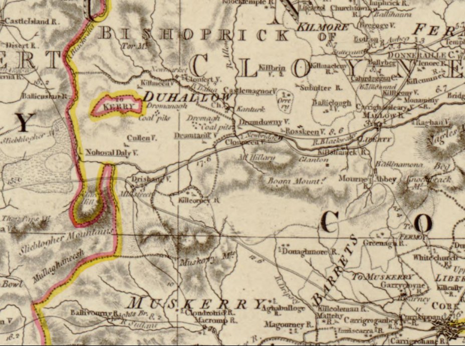
It is not fully clear as to extent of the fraction around Ballydaly. Officially it was just the townlands of Balldaly and Kippagh, but it is mentioned elsewhere in different places that the Ballydaly fraction included Coolanarney and Coomacheo, and the old maps would seem to support this. We have recreated the map below showing the Ballydaly Fraction and the Kilmeen Fraction both enclosed in a red border, and the townlands within each listed, as well as the two townlands that were also mentioned unofficially as being part of the Ballydaly fraction in blue. In the map below, Co.Cork has a light pink background, while Co.Kerry is on the left side of the map with a white background

================================
The official annexation is explained in full in the Wikipedia entry on the East Fractions: (relevant extracts below)
Extract from order in council of 15 July 1843
Proclamation In Council, Dated July 15, 1843, As To Boundaries Of Counties Of Cork And Kerry.
Now We, the Lord Lieutenant and Privy Council of Ireland, having taken into consideration the premises, and likewise the several matters set forth in the said report of the said Richard Griffith, in pursuance of the powers vested in Us, under the provisions of said herein-before recited Act of the sixth and seventh years of the reign of His said late Majesty King William the Fourth, do hereby order and direct, that the said detached portion herein-before first mentioned, to wit, the said detached portion of the barony of Magunnahy, in said county of Kerry, and which is insulated in the barony of Duhallow, and county of Cork, and which comprises the townlands of Doonasteen North, Doonasteen South, Doonasteen East, Derryleeagh, Islandbrach, Loughmanagh North, Loughmanagh South, ITrroghilmore West, and Urroghilmore East, all belonging to the parish of Kilmeen, shall be, and the same are hereby annexed to and incorporated with the said barony of Duhallow, in the said county of Cork:
And We do hereby, in further pursuance of the said lastmentioned Act, order and direct, that the said detached portion herein-before secondly mentioned, that is to say, the said detached portion of the barony of Magunnahy, which is situated between the baronies of Duhallow and West Muskerry, in the county of Cork, and which is for the greater part bounded by the barony of West Musketry, and which comprises the townlands of Ballydaly and Kippagh, belonging to the parish of Drishane, shall be, and the same is hereby annexed to and incorporated with the barony of West Muskerry, in the county of Cork:
================================
The subject was raised on ancestry.com in 2002 in the thread Re: [Cork] Shifting of Cork/Kerry county borders
there was indeed an area of Co. Kerry in the old days, that was totally
within the borders of Co. Cork, near its west border. It is today part of
Co. Cork. My great grandfather came from there. information below. map
can be found in O’Kief series by Albert Casey:
****************
From: <email>
Subject: Re: [Cork] Shifting of Cork/Kerry county borders
Date: Sat, 30 Mar 2002 06:27:30 -0500
In-Reply-To: <119.ef25866.29d4aa3e@aol.com>
Called the East Fractions of Kerry. Maps are found in the O’Kief Series
as follows: Foldout Co. Cork, and Kerry, 1750 maps in front of The Ancient
and Present State of the County and City of Cork, by C. Smith, reprinted in
V. 10 of the O’Kief Series; also, map of 1641 after p. 520, V. 1, O’Kief
series.
From The Ancient and Present State of the County and City of Cork, by C.
Smith, reprinted in V. 10 of the O’Kief Series, p. 294, “A considerable
tract of the County of Kerry, called the East Fractions, is in the center
of this parish” (par. of Cullen).
From p.26, The Ancient and Present State of the County of Kerry, by. C.
smith, M.D., (1756), reprinted in the O’Kief Series by Dr. Albert Casey, V.
10, the following: “A considerable part of Kerry, was formerly a distinct
county in itself, called Desmond; it consisted of that part of Kerry which
lies south of the river Mang, with the Barony of Bear and Bantry in the
county of Cork; and was a palatinate under the jurisdiction of the earls of
Desmond. It is true, the ancient country of Desmond or south Munster,
extended much further, as appears by the grant of K. Henry II, to Robert
Fitz-Stephen and Milo de Cogan, cited at large in my History of Cork(e).
Its limits were from the hill of St. Brandon above mentioned, to the river
Blackwater near Lymore (sp? Lijmore?), and comprehended the county of Cork,
as well as Kerry.
The information in this footnote come from the valuable, but rare, book
Gleanings from Irish History by William F. T. Butler, published 1925 by
Longmans Green & Co. The information from this book is courtesy of Pat
Dineen, 25Mar1997. From Gleanings From Irish History:
From Gleanings, Footnote 14, p. 54, “To the ‘East Fractions’ belonged the
townlands of Ballydaly and Coolecarragh, now in Muskerry, Co. Cork, and
Devilish, Lemenagh, Dooneasleane, Illanbrack, and Baughallmore, now in
Duhallow, as well as the Kerry portion of Noghaval Daly.” Pat Dineen says
the preceeding townlands are probably now (1997) known as Islandav,
Loumanagh, Doonasleen, Illanbrak, and Ruhill(more).
From p. 63, “Also in Magunihy, and in that part known as the East
Fractions, was seated a branch of the great bardic family of O’Daly. This
family, said to be originally from Westmeath, were hereditary poets to
MacCarthy Mor, MacCarthy Reagh, the Earls of Desmond, and O’Brien of
Thomond. In each of the terretories of these lords they had lands assigned
to them, free of all, or nearly all, charges. They held the Kerry portion
of the parish, called from them Noghaval Daly, as well as Ballydaly and
Coolcarragh which were counted, up until recent times, as part of County
Kerry, though surrounded on three sides by Muskerry and Duhallow.”
From p.78, footnote 1, “Herbert. A portion of Duhallow was counted as part
of the ‘East Fractions’ of Kerry down to the nineteenth century. I take
this to have been originally MacCarthy Mor’s demesne”
From p.78: “4. Of Duhallow. In the foregoing pages I have dealt with
twelve of fourteen ‘countries’ which, according to Herbert, were subject to
MacCarthy Mor. There still remain two other territories, those of Duhallow
and Muskerry, corresponding pretty closely with the present County Cork
Baronies so named. In these terretories we find a somewhat different state
of affairs from that existing in Desmond proper. In each the subject clans
did not pay allegiance direct to the overlord; they were subject to the
immediate rule of a chief of the race of Clan Carthy, who in turn was
subject to Mac Carthy Mor. In each, also, Mac Carthy Mor’s rights were
small. Besides “rising out” and the giving of the rod, he had the
‘finding’ of 27 gallowglasses in Duhallow, and of 30 in Muskerry.”
Note from letter from Pat Dineen of 16Apr’97: “As per an old friend in
Ruhill, Dan Sean O’Keefe, the eastern fractions of Kerry seem to have ended
by the Griffith Valuations (1852). My friend made an interesting point, in
that quite a few of the main families of the locality of the Eastern
Fractions had originally come from Kerry. This adds to your Forde family
tradition.
*********************
–On Thursday, March 28, 2002, 12:17 PM +0000 <email> wrote:
> To any who are interested:
>
> I have seen a few postings on this subject, and I have no idea where the
> idea originated. There were some country border changes up in Connacht
> in 1898 (and one in 1840, that I know of) and Waterford lost some land –
> which it’s now trying to get back – also, in 1898. But I have
> absolutely no information of county border changes between Cork and
> Kerry since the early 1200’s, when they were both shired (and the names
> were changed to “counties” later, but with no boundary changes). I’m
> sure that much of this speculation comes from PLU’s and Registration
> Districts, which were centered around major towns and occasionally
> extended beyond county borders – thus confusing the
> genealogist…..again. Also, emigrants who left from Queenstown/Cobh,
> Co. Cork, were often listed as ‘coming’ from there, whereas, in fact,
> that was only their port of departure.
>
> But…….if anyone has any definitive information on border changes
> between Co. Cork and Co. Kerry within, say, the last 700 years…..I’d
> appreciate hearing about it, so that I can add the information to my
> maps/files. Thanks in advance.
=====================================
The question was later partially answered in 2006 on ancestry.com: East and West Fractions (Cork/Kerry boundaries)
From Lewis’s Topographical Dictionary:
“FRACTIONS, EAST AND WEST, detached portions of the barony of MAGONIHY,
county of KERRY, and province of MUNSTER; the former being locally situated
in the parishes of Drishane, Kilmeen, and Nohoval-Daly, in the barony of
Dulhallow, county of Cork, and the latter in the parishes of Glenbegh and
Killorglin, barony of Magonihy, county of Kerry, containing in the whole
5296 inhabitants, of which number, 285 were in Drishane, 1045 in Kilmeen,
1304 in Nohaval-Daly, containing altogether 2634; and 616 in Glenbegh, and
2046 in Killorglin, together amounting to 2662 inhabitants. In the
ecclesiastical divisions they are considered parts of the parishes
enumerated.”
In other words the East Fractions were bits of County Kerry surrounded by
County Cork, the West Fractions were within Kerry, being a detached bit of
Magunihy barony.
An Act of Parliament was passed in 1836 (6&7 Will.IV c.84) which allowed the
Lord Lieutenant to “incorporate certain detached Portions of Counties and
Baronies with those Counties and Baronies respectively wherein the same may
adjoin, or wherein the same are locally situate.”
======================================
The Fractions were also mentioned in “A Topographical Dictionary of Ireland, 1837“
FRACTIONS, EAST and WEST, detached portions of the barony of MAGONIHY, county of KERRY, and province of MUNSTER; the former being locally situated in the parishes of Drishane, Kilmeen, and Nohoval-Daly, in the barony of Duhallow, county of Cork, and the latter in the parishes of Glenbegh and Killorglin, barony of Magonihy, county of Kerry, containing in the whole 5296 inhabitants, of which number, 285 were in Drishane, 1045 in Kilmeen, 1304 in Nohoval-Daly, containing together 2634; and 616 in Glenbegh, and 2046 in Killorglin, together amounting to 2662 inhabitants. In the ecclesiastical divisions they are considered as forming parts of the parishes above enumerated.
=========================================
The fractions were mentioned twice in “The origin and development of the Parish of Millstreet” by Fr. Sean Tucker (2008)
page 12: The diocesan boundaries existed before the county boundaries, which were a Norman innovation. The territory within the diocese was predetermined at least a half a century before the county boundaries were drawn up.
However, nothing is ever simple. It is further complicated by the fact that the townlands of Ballydaly, Kippagh and Comachoe were regarded as part of the East Fractions of Kerry for about 300 years and the townlands of Shanaknock, Annagloor and Clarathlea were part of the Barony of Duhallow, which extended south of the river Blackwater, as far as Clara mountain.
page 26: Fr. Ferris would have said Mass in the ruined Penal church in Ballydaly Upper, located about 250 metres south of Croohig’s cross. We come across him again in information supplied to the Sheriff in June 1714 and an order of capias (let him be arrested) was issued against him on July 17th 1714. Details of the pursuit of this warrant are not forthcoming but in 1715 he had succeeded Anaes Lyne, deceased, in the parish of Kilcolman. In this instance Ballydaly is called the Parish of West Fractions. The above details are accumulated from State papers at the time and extracts from these can be found in “Irish Priests in Penal Times” by W Burke (1969 p.l49f).
—-
I wonder why they were called the Parish of the West Fractions, since they were otherwise referred to as the East Fractions? can anyone help?
=========================================
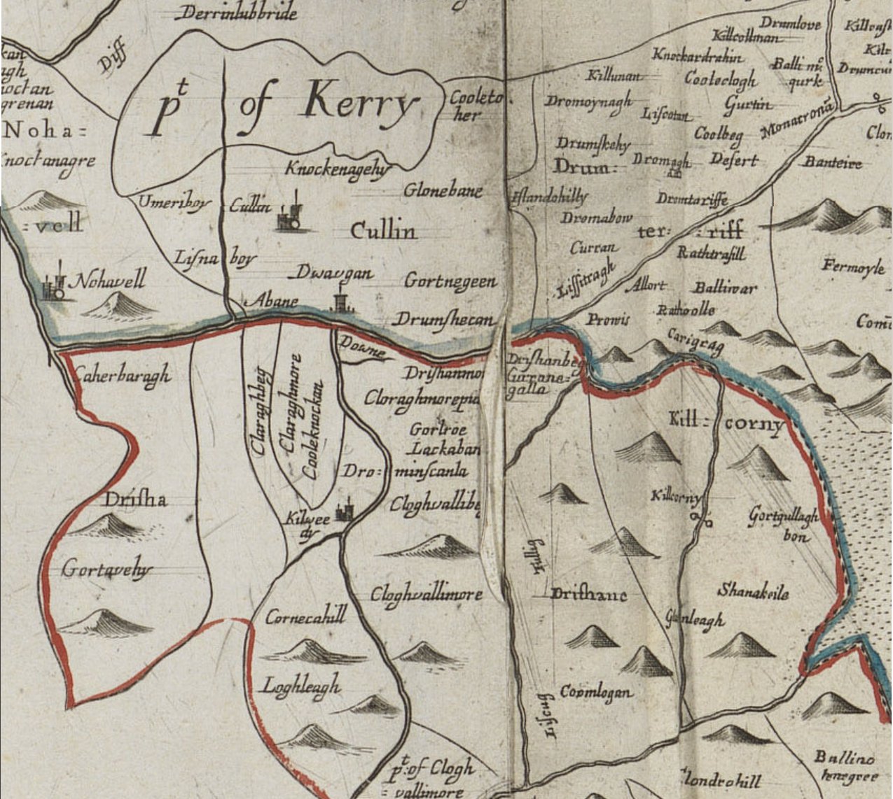
The Fractions are also seen in the local Down Survey Map from approx 1659 and they would appear to show Coomacheo as part of Kerry County.

=========================================
=========================================

=========================================
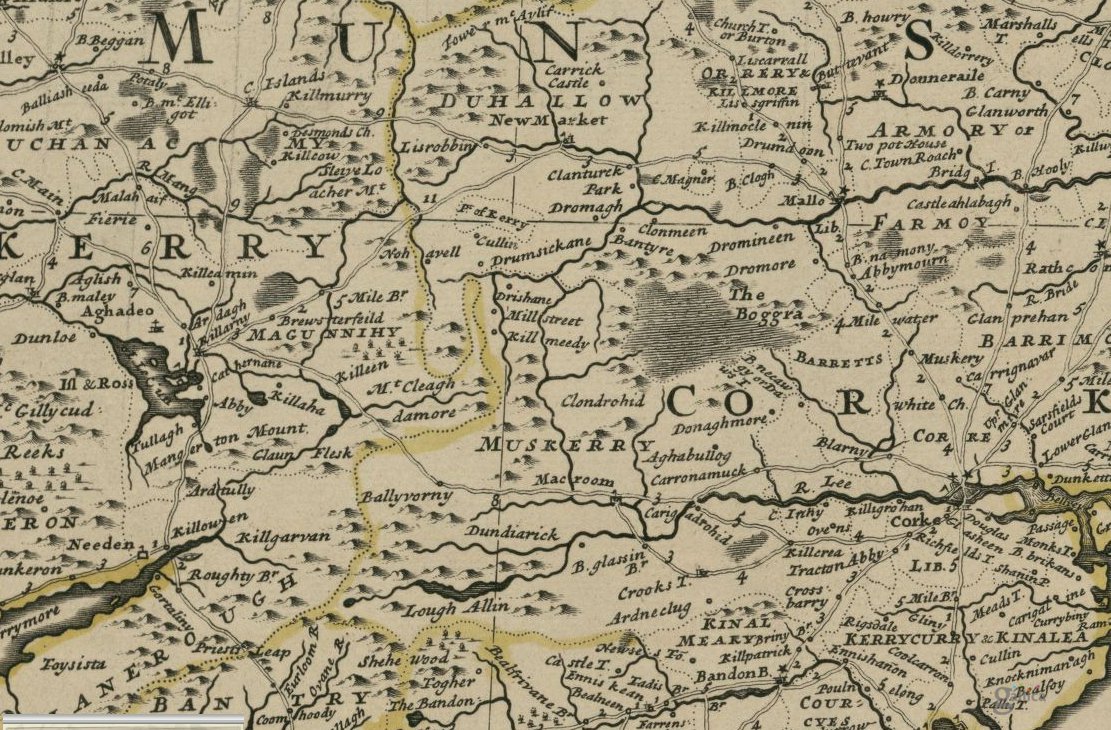
The barony of Magunihy takes in an area of Kerry from west of Killarney to Rathmore. It is shown in the below map of Baronies, parishes, townlands (from ancestory.com)

=========================================
It is also noted in the Wiki East Fractions page that “Ballydaly and Nohovaldaly are called after the Daly (Ó Dálaigh) family of poets.”
Again Fr Sean Tucker has a detailed description of the O’Daly’s in his book: “The origin and development of the Parish of Millstreet” (pages 30-36) of which the below is just the start:
The O’Dalys of Nohoval and Ballydaly.
The O’Dalys were the most renowned and fruitful brood of professional poets in this area. They originated in County Westmeath and moved to the Cork/Kerry area in the 12th Century. They became professional poets to the McCarthy Mores and the McCarty Reaghs. In the words of John O’Donovan “There is certainly no family to which the Bardic literature of Ireland is more deeply indebted than to the O’Dalys”. The most prestigious names associated with this area are, Geoffrey and Aengus Fionn O’Dalaigh and Aengus Rua the satirist.
=========================================
TODO: it would be good to locate and read the book mentioned below in a comment by Denis O’Connor. (mdc)
Right Brother Reverand Sean O’Connor OSA (Order of Saint Augustine) and Doonasleen wrote a book on the Eastern Fractions. Brother of Mrs Peggy Murphy, Lisnaboy and the late Donal O’Connor MCRVS (Member of the Royal College of Veterinar1y Surgeons).
Administrator’s note: The above is a long hand version of the original comment from Denis below which was in shorthand.
“rbrev sean oconnor osa and doonasleen wrte abook on eastern factionsbro ofmrspeggymurphy lisnaboy and late donal oconnor mcrvs”
thanks Denis, would i be right to say that the vet Donal O’Connor you mention was based in Minor Row, Millstreet for many years? and also that the said Rev Seán O’Connor OSA is now in Dungarvan?
by any chance, you don’t know the name of the book, and / or where one might be able to read it?
Name: Eastern Fractions. Mrs Peggy Murphy, Lisnaboy, Cullen his sister in Cullen may know more. Fr. Sean has many nieces and nephews in Knocknagree / Cullen area. Also my copy is not accessable now.
— original message–
NAME EASTERN FACTIONS MRS PEGGY MURPHY LISNABOY CULLEN HIS INSINISTER MAY KNOW MORE FR SEAN HAS MANY NICES NEWPHEWSI.NKNOCKNAGREE CULLEN AREA ALSO MYCOPY IS NOTASSESABLE NOW
Thank you to Denis O’Connor for the Forde of Loumanagh Griffith information.
Looking for any information on Forde from Loumanagh townland in the East Fraction. My g. Grandfather Forde was traced to there.
Thanks
<email>
Looking for information the McSweeneys and Collins of Kippagh just south of New Market in County Cork. Hanora McSweeney married a Collins and they lived on the McSweeney farm in that area from the 1870s to the turn of the century