

Recently I became aware that the 1911 Census has been published online at http://www.census.nationalarchives.ie. So if you would like to find who was in your house the night of that census, or if you would like to trace your ancestors then this is an interesting place to look. Personally, I have found my own four grandparents and my 7 great grandparents that were still alive then, and some more interesting facts too.
In this census, Millstreet Town is not a district, but is split into two separate DEDs (District Electoral Divisions): Coomlogane and Drishane from the days of the great houses in town. The full list of local DED’s are:
Caherbarnagh, Coomlogane, Drishane, Kilcorney, Crinaloo, Rathcool,
Keale, Cullen, Skagh (Derinagree), Knocknagree, Rosnalee, Doonasleen
note: the Derragh DED which was in the 1901 census is now gone and is part of the Cullen DED in 1911.
The census was taken on April 2nd 1911.
An interesting thing was the inclusion of Coomlagane Street and Riordans Lane in the Coomlogane District, and Bank Lane in the Drishane district, which I can’t find on old maps. Probably renamed in the meantime, but does anyone know where these started and finished? I suspect Coomlagane Street is now the Main Street and the West End, because it includes census details for the Presentation Sisters and also the Justice family (which I assume was the bakery). I wonder if Bank Lane was down by the side of the Bank of Ireland Building, or if it was where bank place is now, though the AIB was not built until 20 years after this census. It would be good if someone could us out please!
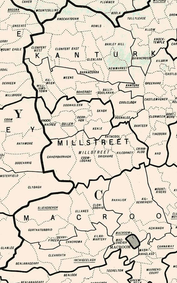
We list below all the local Electoral Divisions (in large print) and all the townlands in smaller print
- Ballydaly
- Caherbarnagh
- Coolanarney
- Gortavehy East
- Gortavehy West
- Inches
- Kippagh
- Knockagallane
- Knocknaloman
- Rathduane
- Toorboney
- Adrivale
- Annagloor
- Ballynatona (Ballinatona)
- Ballyvouskill
- Caherdowney
- Carrigacooleen
- Carrigleigh
- Claragh Beg
- Claragh More
- Claraghatlea North
- Cloghboola More
- Coolykeerane
- Coomlogane
- Coomlogane Street
- Curracahill
- Curragh (Currah)
- Derreen
- Ferm
- Geararoe
- Gneeves
- Inchileigh
- Killarney Road
- Kilmeedy East
- Kilmeedy West
- Knocknakilla
- Lower Mill Lane
- Mountleader
- Riordan’s Lane
- Shanaknock
- Tober
- Bank Lane
- Church Street
- Cloghboola Beg
- Coole
- Cooleenaree
- Dooneens
- Drishane More
- Drominahilla
- Garraneduff
- Lackabane
- Lackdotia
- Liscahane
- Liscreagh
- Main Street
- Manor Row
- Mill Lane Lower
- Mill Lane Upper
- Mushera
- Pound Hill Street
- Tooreenbane
- Tullig
- Baunreagh
- Brookpark
- Donoure East
- Donoure Middle
- Donoure West
- Drom Beg
- Finnanfield
- Glebe
- Glenleigh
- Horsemount Mountain
- Horsemount North
- Horsemount South
- Kilcorney
- Killeen
- Knockanroe
- Knockgorm
- Laharan
- Mushera
- Shanakill
- Ballinkeen
- Boolymore
- Coolnagillagh Lower
- Coolnagillagh Upper
- Drishane Beg
- Killowen
- Knockcahil
- Laght
- Prohus
- Rathcool
- Cleanrath
- Dromsicane
- Garrane North
- Garrane South
- Garrane West
- Gortageen
- Gorteennafinnoge (Gurteenafinnoge, Ploverfield)
- Keale North
- Keale South
- Kealmanagh
- Killetragh
- Lisnashearshane
- Lyravuckane
- Minehill
- Moher
- Rathroe
- Ahane Beg
- Ahane Lower
- Ahane Upper
- Ardnageeha
- Ballinvragnosig
- Boulaling
- Church Hill
- Coalpits
- Cullen
- Cullen Town
- Derragh
- Duarrigle
- Euglaune
- Glantane Beg
- Glantane More
- Glinny
- Gortnacreha
- Knockagarrane East
- Knockagarrane West
- Knockane
- Knockduff Lower
- Knockduff Upper
- Knockeenadallane
- Knockeennagearagh
- Knocknageeha East
- Knocknageeha North
- Knocknageeha South
- Knocknageeha West
- Knocknashannagh
- Lisaniska
- Lisheenafeela
- Lislehane
- Lisnaboy Lower
- Lisnaboy Upper
- Meenagloghrane
- Milleenylegane
- Mullaghroe North
- Mullaghroe South
- Piercetown
- Slieveroe
- Two Gneeves
Skagh (Derinagree)
- loonbannin East
- Cloonbannin West
- Coolcloher East
- Coolcloher South
- Coolcloher West
- Dernagree
- Derrynatubbrid
- Drominagh North
- Drominagh South
- Island Dahill
- Knockacarracoosh
- Knockastuckane
- Maulyclickeen
- Meenskeha East
- Meenskeha West
- Skagh
The present West End, Millstreet was once known as Coomlogane Street – Even to this very day West End residents receive letters addressed to Coomlogane Street…and to my knowledge…the original address is still used in voting registers. Coomlogane House was of course situated in what we later called The Lawn …now the Town Park…and one of the visitors, we believe, to arrive on a regular basis to the McCarthy-O’Leary owned residence was the famous Daniel O’Connell. Yes, the Justice Family had a Bakery in Coomlogane Street. Later this famous Bakery moved to Main Street to a setting which was once owned by the Hegarty Family of Pound Hill, Millstreet. The fame of Justice’s Bakery spread far and wide over the years with such hugely popular products such as the hot cross buns, the brown square, delicious confectionary and superb Christmas cakes!
Riordan’s Lane, the Lane near Nibbles – there was a forge in that Lane also…and I believe there was a Riordan Family living close by.
Bank Lane could have been down by BOI or perhaps McCarthy’s Lane as I feel there were dwellings behind those houses.
Also, the person in charge of the Ireland’s most recent census is of course a Millstreet native – Donal Garvey (who, I believe, is now retired).
Sean – Thanks for explaining this. I reviewed the census Late last week and found my great grandparents, Denis (65) & Honora (65)Dennehy and son Michael(36)at 26 Coomlogane Street, and I had no idea where it was, other than somewhere in the West End. To your knowledge, is there anything in that particular area now?? Thanks again for everything you do. Joe & Marie
Thank you for posting this, I found this a few weeks ago myself. I believe they are working on the 1901 census at this time and plan to have it online by the end of the year.
I have found my great, great, great grandfather and grandmother living with one of his daughters (my great great grandfathers sister) which confirmed a lot of things for me!
My great great grandfather came to the US (to Pittsburgh, Pennsylvania) in 1895 and it’s been hard to track down to Ireland prior to this. I have information on him and his brothers that they came from Millstreet so this was a great find.
If any Kelleher’s (descended from Tim and Ellen) or Carrolls (descended from Kate Kelleher Carroll and Daniel) would like to exchange information please let me know! I’m always trying to make links back to Millstreet!
Presley Kelleher
presleyk|at|verizon|dot|net (replace |at| with @ and |dot| with .)
I am currently researching my family history and would like any information about the family of Abina McSweeney who left her home, along with her sister Kay, in Carriganima in the 1940s. She came to England and married John Coyle in 1948 in Lincolnshire. I remember her telling me that her father was a postman who had a large family. I have met some of them in the past but have since lost touch. If any one with information could contact me I would be highly delighted.
Many thanks in anticipation.
Wendy Aston (previously Coyle)
Hello Wendy,
My grandmother Julia McSweeny was born in Carriganima. Her parents were Willian and Catherine Duggan McSweeney. Their last name is spelled McSwiney on the 1911 census. Her brothers and sisters were John, James, Hanora Kate, Patrick, Albina, Daniel, William and Elizabeth. William McSweeny was the postmaster in carriganima or Carriganimmy and they lived in the post office. Julia, Patrick, Elizabeth and Daniel came to America. If I can help you in any way please contact me at <email>
Rich Fennessy
Hi,
Im looking for any infomation on the Buckley/ Corcoran family from Coomlogane, parish of Drishane, near Millstreet, Cork. Mary Corcoran married Patrick Buckley c. 1899. They had at least 8 children. Tim, Pat, Catherine (my grandmother), Dan, Denis, Margaret, Hannah, Nora.
Any info would be great.
Thanks
Eve
Re: Lehanes of Ballydaly
Hello. I have been doing genealogy for many years now. I’m familiar with the Millstreet birth and marriage (Glenflesk Parish, Kerry) online records from the Department of Arts, Sports and Tourism, and the 1901 and 1911 Ireland Censuses online. Great places for research!! I know about my Lehane ancestor’s emigration to America (Massachusetts, some via New York) and have found many others related to my Lehanes in America. I am so glad to know about your wonderful website on Millstreet.
If there are any Lehanes related to Stephen Lehane and Honora Kelliher, both born in the 1830’s, then that is a good place to begin. They were married in 1860. They had 11 children. Through birth records, I found that some of their children were born in Dooneen, some in Droumsicane, some in Coolekerane, one in Shanaknac, and one in Ballydaly. I’m guessing the towns are all in one area. Stephen and Honora were the parents of my great-grandmother, Julia Maria Lehane. Julia emigrated to Massachusetts to marry my great-grandfather, Patrick Kell(e)y, formerly of Ironmills, Glenflesk.
I’m hoping to find a Millstreet family connection to this Lehane family.
Thanks for your time.
~Patsy
I am noticing a large gap in the Church records 1800-1850s. This is when my ancestors were being born, baptized and married, before migrating to America. Is this because the churches were closed?
The family from Mount Leader was Daniel McAuliffe, married to Ellen Murphy. Their daughter was Abbie, born about 1845.
The Millstreet people were Kellehers or Kellihers. John Kelliher, Jr., born about 1847. His parents were John Sr. and Margaret Murphy. He had a sister Margaret, also born in Millstreet.
Any information is very welcome! Thank you! Joan
My great grandmother, Julia Murphy, and two of her children (Hanoria and Michael) are listed in House 4, Knocknaloman, Caherbarnagh in this census. The home is still in the family, owned by the great great grandson of Julia and great grandson of Michael Murphy. I have visited the home several times over the past 20 years and look forward to another visit since becoming an Irish citizen.
Trying to sort out my mother’s family. Moriarty. What DED would Carrigacooleen be in for the 1911 census?
My great grandfather was Batt Moriarty, farmer, and his will is dated 1891 signed by John Murphy, Parish Clerk and by Arthur Dillon CC, Carrigacooleen, Millstreet. His son Tim emigrated to Glens Falls NY where my mother was born. In the will mentions son John and daughter Margaret. I researched The Boys of Mill Street and see a John Moriarty and am trying to see if that could be my great uncle.
Thanks for any assistance.
Hi Jane,
Carrrigacooleen is in Coomlogane. There is a link to it in the article above.
Batt Moriarty died on October 20th 1891. In his death register, it mentions that your grandfather Tim was present at his death.
https://civilrecords.irishgenealogy.ie/churchrecords/images/deaths_returns/deaths_1891/06051/4724602.pdf
Your grandfather Tim Moriarty was born on November 26th, 1865 to Julia Riordan and Batt Moriarty of Carrigacooleen.
https://civilrecords.irishgenealogy.ie/churchrecords/images/birth_returns/births_1865/03548/2306117.pdf
Apparently he had a brother John, and four sisters: Hanna (Murphy), Ellen (Corcoran), Margaret (Sullivan), Mary (Moynihan)
Have you a cousin Kathy Flock, a descendent of Mary Moynihan who looks like she has most of the Moriarty family tree on ancestry here:
https://www.ancestry.co.uk/family-tree/person/tree/170670404/person/362214309303/facts
I’m curious, did Tim emigrate with his wife to be Kate Cronin, or meet her in Glens Falls, as she was also from Millstreet?
Lots of people from Millstreet emigrated to Glens Falls at that time. Did he go out with his wife to be Kate Cronin
The parish clerk, Jack Murphy, was known as Jack the Clerk. We have an article on him here:
http://www.millstreet.ie/blog/2016/03/20/jack-the-clerk
Thanks for the info. Do you know anything about Tim’s brother John. I found marriage record for Jan 1900 and baptism for two sons Bartholomew and John, born 1900 and 1902 respectively. Do you know if John or his son may be the John Moriarty in “The Boys of Mill Street?”
the moriarty family still in the same area i may be able to help you